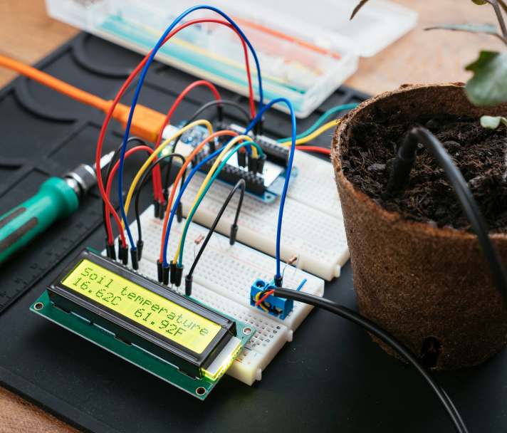
"Without FME Server we would have had to build a custom solution, and the estimate just for a prototype solution was six to seven months."
Jim Saini, Pelmorex Corp.Sensors are commonly used stand-alone or in devices to collect data and detect changes in our environments. If you happen to be using any kind of “smart” device like a phone or watch, you’ve likely seen how these sensors can be useful in providing valuable insight about your day to day life. With all of this data being collected, it just makes sense to start tuning into sensor data.
Sensor data is being collected 24/7, so it’s important to have an efficient integration system in place to ensure you can always be making data-driven decisions. With FME you can set up event-triggers to allow workflows to run automatically, collecting new incoming sensor data and integrating them with your other datasets in real-time. FME can help you connect to a single sensor of interest or an entire network of interconnected devices. It’s up to you! Let data become your sixth sense.
Why FME for Sensor Data?
Connect to Sensor APIs
Many sensors and devices with built-in sensors have APIs that you connect to directly in FME. Use transformers like the HTTPCaller to manage calls from REST, SOAP, or HTTP that trigger your integration workflows to run immediately.
Real-Time Data Collection and Integration
Using other sensor devices or IoT technology without APIs? No problem. For sensor devices using internet networks, use transformers like the TCPIPReceiver to obtain packages of information via TCP/IP.
Validate and Detect Outliers
Sensors can help you understand what conditions are normal, what kind of fluctuations to expect, and when to expect them. Set up validation workflows that detect when there are anomalies in your dataset.
Get Notified
Use FME Server to set up notifications that tell you and other users what and when changes have occurred. From summarizing data from the past day or week to alerting you of an unusual data point, FME can help!
Visualize Events Live Online
Convert data collected from your sensors to formats like KML or SHP for use in platforms like Google Earth or ArcGIS Online to update users about how and where events you’re monitoring are taking place.
Free Support!
No matter where you are in your FME journey, we are here to help! Visit the FME Community to discuss your data journey with other FME users and our experts, or reach out to us via Live Chat for further assistance.
FME for Wayfinding
Indoor mapping has become a great way to make navigating large venues like airports, malls, and arenas easy for visitors. The process requires two main components: sensors that track the location of a map user via their phone, and detailed models or blueprints of the indoor facility. By using wayfinding technology, vendors can identify how to make better business decisions based on how their customers use their space.
FME can help with both connecting to sensors and optimizing building blueprints. When it comes to creating maps, FME has you covered. Convert your CAD or BIM files to formats like IMDF for Apple Maps to make your facility map accessible to the public. Then, if you’re up for it, create an augmented reality wayfinding app with a little help from FME AR.
FME for Smart Cities
More and more cities are turning towards IoT devices and other information and communication technology to identify how, when, and where events are taking place. Doing so can help a city make data-driven decisions that result in happier and healthier communities.
FME can connect to a variety of IoT resources including sensors, energy meters, and other important city data systems like Cityworks and Socrata to help you align all your data resources. Use FME Server to trigger running your workflows as soon as you receive data from any of your sources to ensure you’re never behind in your data efforts.
FME for LiDAR and Point Clouds
In remote sensing, sensors like LiDAR technology are used to detect features on the Earth’s surface. By actively emitting light and using a sensor to record the signal that is returned, detailed information about a given location can be recorded as a point cloud.
Point clouds are one of FME’s specialties. This 3D format has a whole category of transformers dedicated to them. Use these tools to modify your LAS, XYZ, and other point cloud formats to create something new, or simply extract the collected attributes and integrate them with your other existing data.

FME for Radar
Radar technology is another popular form of remote sensing. Radio waves are emitted towards an object or surface, and the returning wave is detected by a sensor. This kind of sensor is great for tracking moving objects like ships or aircrafts and for mapping features underwater.
Whether you’re using IRIS to monitor weather events, SRTM HGT for analyzing topographic data, or RADARSAT-2 for collecting data on natural resources, FME is here to help.