Tight timelines, limited budgets, and no access to developers didn’t slow down prototyping for Sterling Geo
Awarded a grant by the UK Space Agency, Sterling Geo needed to deliver between 1 and 100 applications in one year to public sector and government organizations, demonstrating the value of earth observation data derived from satellites such as Landsat and the Sentinel series. The aim of the project, named 100:1, was to create a pragmatic, sustainable and affordable approach to the long-term use of earth observation data. Their objectives were to deliver services, not technology, around the needs of the clients, without capital investment, training, or major IT infrastructure changes.
“The challenge that Sterling Geo faced was standing up as many applications as possible in a very short period of time, without a pool of developers to create functionality,” explains Gavin Park of Sterling Geo.
The team did not have any developers to add to the challenge, and they needed to collect as many applications as possible under a short deadline.
How they made it possible – no code required
Sterling Geo deployed FME in the cloud, meeting the satellite data where it’s housed on AWS under Amazon’s Open Data Program. This allowed the powerful server environment to be stood up and used for the duration of prototyping, and only paid for during demonstrations. It also enabled no infrastructure changes upon deployment into production.
Equipped with the technology, Sterling Geo set out to identify scenarios where earth observation data could solve the problems that government agencies were facing. Here are three inspiring examples.
Use Case: Automated vegetation health monitoring
The most popular use case with nearly 80 local authorities and government departments expressing interest was related to satellites’ ability to pick up the near-infrared light that plants give off when they photosynthesize. Ongoing analysis of this data could provide monitoring of plant health and quantity of greenery in cities.
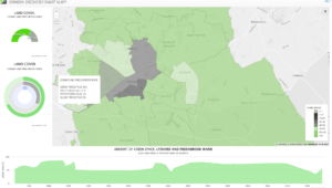
The Automated Vegetation Health Monitoring app provides a web client showing statistics summarized in graphs and on a web map. Users can choose to be notified via email as new information becomes available.
Triaging relevant imagery updates
Gavin’s team set out to provide this information in a web service. Because satellite data is continuously being gathered, they didn’t want users to be inundated with data. Instead, they designed the service to only notify users when new information, not data, became available. Once data is converted into relevant information, users are notified via an email notification.
Use Case: Slack & email data delivery
Several government agencies were interested in being notified when new satellite imagery was available for their region of interest, if it met their specific criteria.
This functionality is especially useful when users want to see the raw data imagery, but don’t understand how satellite images are collected, nor how to do a catalogue search; they just want to download the image scene. In the UK especially, where it is often cloudy, this kind of email notification is helpful, as users are only notified when relevant data is available with limited to no cloud cover.
“FME’s ability to send notifications via email and Slack was invaluable, as we could disseminate the information to teams as soon as it was available,” Gavin describes. “We used FME to dynamically generate HTML content and include this in an email to be sent out. Operating in the cloud, it was possible to embed the download links directly from S3 into this email as well, eliminating any additional data storage costs.”
Use Case: Fire-related building development status
The Fire and Rescue Service wanted to verify the data they have regarding new builds’ development status by comparing it to satellite imagery. An app was built to check the available data for addresses, statuses such as in development, complete, and planning permission granted, and allow users to cross-reference this with aerial imagery or high resolution satellite imagery to see what’s actually happening on the ground.
Specifically, FME is used to extract this data from the Ordnance Survey AddressBase product, and then to scrape a housing development website for all locations of new builds. The FME workflow then calculates the statistics for the properties of each ward, and assigns hex colour codes to each property based on its status (% of new or planned builds).
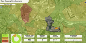
The FME workflow outputs the resulting data as JSON to be easily be consumed by the web page and the chart API. This allows a spatial dashboard view to be created, displaying areas of new development which can be easily explored. The dashboard is displayed against the imagery layer, providing context and reference. It also allows the fire and rescue service to visually identify prospective nearby water sources in case of emergency.
A successful prototype
The 100:1 project has certainly achieved what it was commissioned to do.
Gavin and his team have worked with over 150 government agencies to identify and build approximately 20 apps to leverage this data so far. Prototyping was quick and inexpensive, with servers on the cloud only paid during demonstrations and no infrastructure changes upon deployment into production. Many of these apps are now being used in production and have enabled users to understand firsthand how EO monitoring can be fed into strategic planning cycles.