Understanding the principles behind situational awareness can help highlight gaps in spatial data systems and provide insights for improving their capabilities and effectiveness. In this article, I’ll outline key aspects of situational awareness, specifically the addition of a time component, and how this can be applied in the geospatial data context.
We’ll look at examples from a local scale and a regional scale to illustrate the practical implications of this, including the digital twin of an airport, a disaster management and response system for a river basin, and a regional utility such as a natural gas company.
What is Situational Awareness?
According to Wikipedia, “situation awareness is the perception of environmental elements and events with respect to time or space, the comprehension of their meaning, and the projection of their future status”. This term has many possible areas of application, such as military and emergency / disaster response, facilities, infrastructure, and utilities management.
Situational awareness has three key components:
- model of elements in the environment
- comprehension of current status
- projection of future status
The main idea is to build systems that allow us to better monitor and understand what is happening around us and provide the information necessary to better adapt to our changing environment.
The Limitations of Traditional Geospatial Data
From a geospatial data perspective, historically, many GIS and CAD systems had a focus of maintaining datasets that represented some point in the past. Perhaps the data is based on some survey, plan, design, or as-built document. Or the data may have been digitized from remote sensing data from air photos or satellite imagery from some time in the past. Regardless of how it’s acquired, any of these approaches are inherently historical in nature. The data derived from this is only accurate as of a specific time in the past. Observations made from this data today involve making inferences and assumptions that, at best, have some degree of uncertainty and at worst, are highly suspect.
The challenge then is: how can situational awareness be used to enrich spatial data systems so an understanding of our environment is more current and accurate, and therefore the decisions based on our data are more relevant and effective?
Adding a Time Component
A number of trends in the IT and geospatial sectors address this need. One area that has seen significant advances is real-time data stream support, including live data stream services (e.g. weather or news updates) and Internet of Things devices (IoT, e.g. thermometers, cell phones). However, the benefits of real-time data are not fully realized or understood until these observations are fully integrated into our current model of the environment or infrastructure we wish to manage. Because of this, the concept of digital twins has emerged as a central focus for data modeling and management systems. While there are many definitions for ‘digital twin’, the main concept relevant to situational awareness is the addition of time to all relevant data. Is a particular data view from the past, present, or a projected future? This can be applied to everything from a local scale, such as a building information model (BIM), or to the planet as a whole, such as a climate model, or anything in between, such as urban digital twins (also referred to as smart cities). The key is integrating sensors and real-time data feeds so we have a better understanding of the present, as well as integrating forecast and trend models so we have a better appreciation of possible futures.
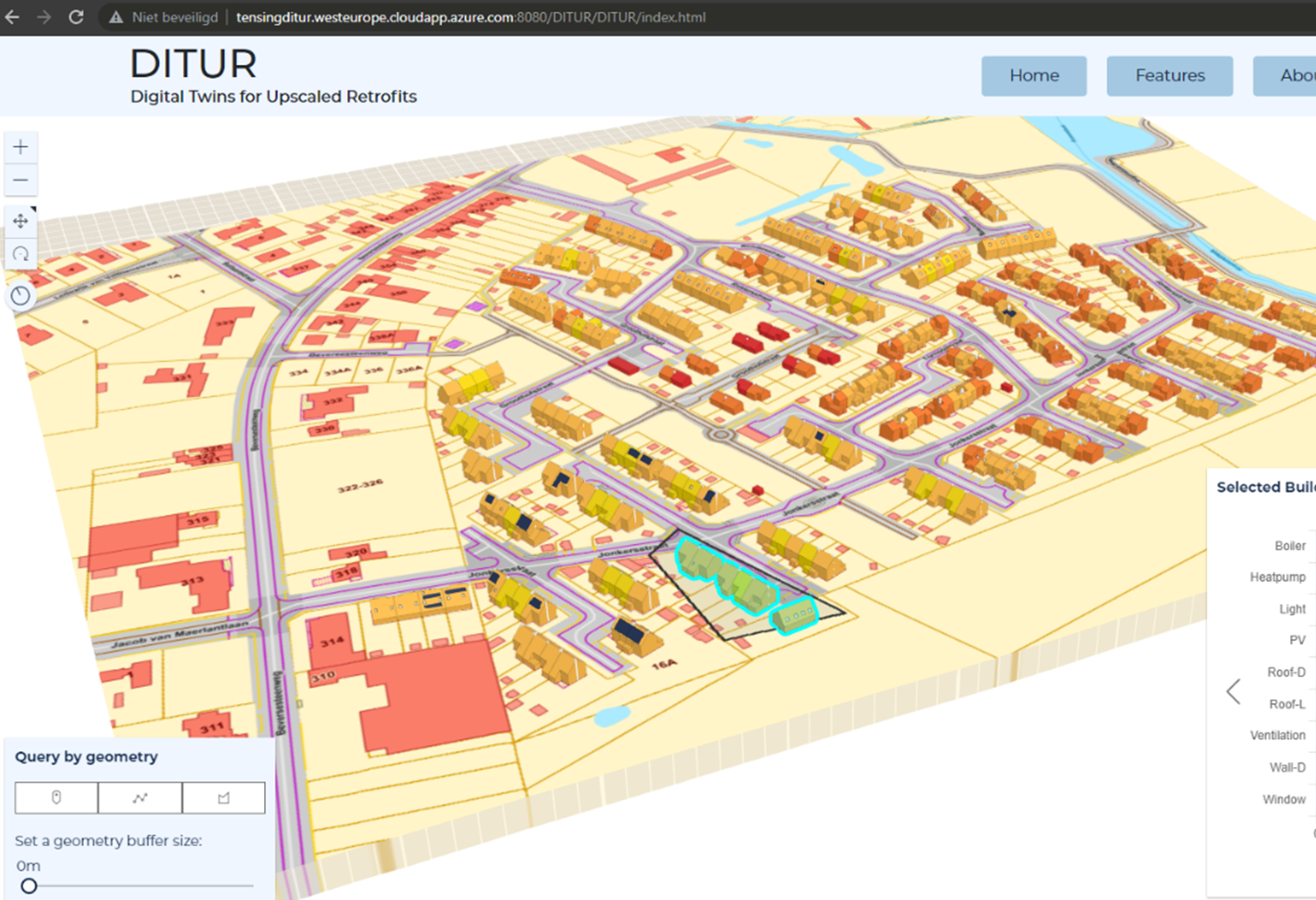
Solar power potential – DITUR project by Tensing / Avineon
Application: Situational Awareness for Airports
For an airport like YVR or SFO, it is crucial that managers have a complete understanding of what is happening at any given time. It’s not enough to have access to floor plans and runway layouts. Managers need a real-time view of where each aircraft and support resource is located at any given time. In order to manage the terminal space, there needs to be a current understanding of where people are, where they might want to go, what areas are restricted, and to what extent. All of these aspects have a time dimension. A wing of a terminal may be designated domestic one week and international at a later date. A section of a taxiway may need to be closed for maintenance. Different zones within the airport may only be open at specific times of day or only accessible by authorized staff.
To better support this dynamic nature of an airport’s information, we need both a data model that supports this time-sensitive view and data streams such as sensors to update the model at a suitable frequency. Something as simple as an indoor map can be created from basic physical information like a floor plan from CAD or BIM. However, its utility is limited until the amenity and occupancy information is added. This includes information about what store occupies a particular commercial space and what their opening hours are.
So the situational awareness in this indoor environment needs to include data feeds that provide regular updates on occupancy and operating hours, plus a data model that has a place to update and store this status information. With this daily update of information, a basic floor plan becomes a simple digital twin of the indoor space, which enriches the dataset and can support apps to help people get what they need from where it’s available. In this case, the OGC IMDF standard data model has the capacity to store the physical information of building levels, units, and hallways, as well as the contextual information of occupancy and amenity types so people can find what they want and see how to get there.
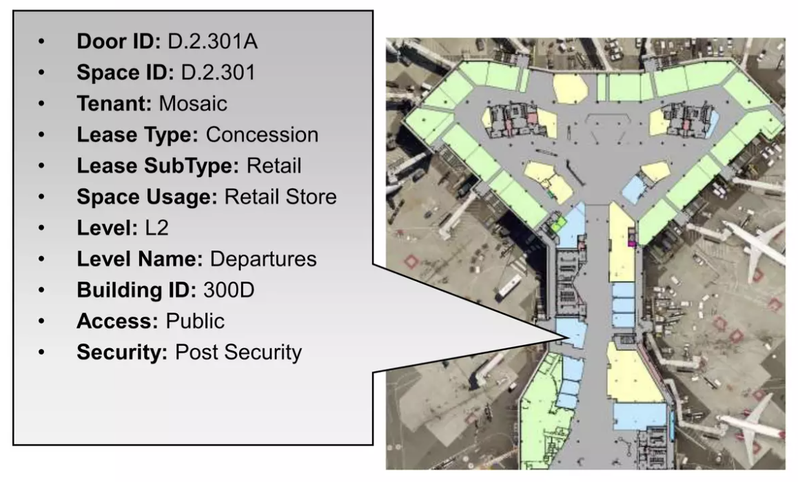
Screenshot from a presentation by San Francisco International Airport (SFO)
Application: Situational Awareness for Natural Gas
FortisBC illustrates this principle on a wider scale. Not only do they manage the largest gas distribution network in the region, but they also need to protect it from natural hazards that change over time. To protect their network from fire hazards, FortisBC uses FME to monitor active wildfire data from BC Wildfire Branch on DataBC and integrate it with their asset and network data stored in GE Smallworld. This data is checked every 2 hours, and for any assets that fall within a 10km radius of an active fire zone, automatic notifications are sent out to the regional managers responsible for them. Threats to other critical infrastructure such as schools and hospitals are also tracked.
In this case, existing infrastructure data of the gas network and its facilities is enriched with fire risk information to provide an operational view of ongoing hazards and allow managers to make timely decisions to protect those assets and personnel. FortisBC did not need to employ their own sensor network. Rather, they simply needed to integrate with data from the BC Wildfire Service.
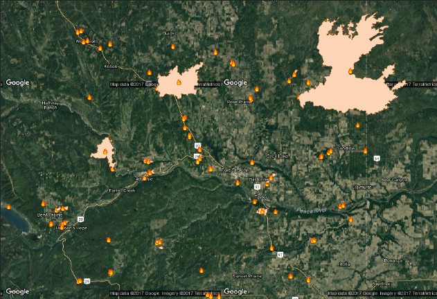
BC Wildfire Service web map
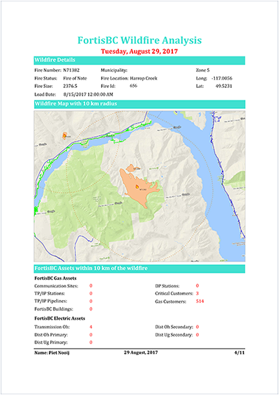
FortisBC report for operations managers
Application: Disaster Management and Response for a River Basin
Both examples above show how blending site and infrastructure data with real-time monitoring allows historical data to be updated to reflect current conditions. However, full situational awareness also often requires anticipating what conditions are likely to occur in the near future. In the case of mitigating risk, it’s not enough to know what the hazards are today. We need to assess risks based on what the likely hazards are tomorrow, next month, or next year. The more lead time, the less expensive the mitigation is likely to be.
One of the most important and challenging cases to consider in this context are impacts due to climate change. We know from recent experience that using history to estimate future risk is no longer a useful guide. Many regions have seen multiple ‘500-year’ floods in less than a decade. Following the principle above, instead of just combining our infrastructure data with real-time data streams, we also need to generate future scenarios by combining current infrastructure data with forecast or trend models.
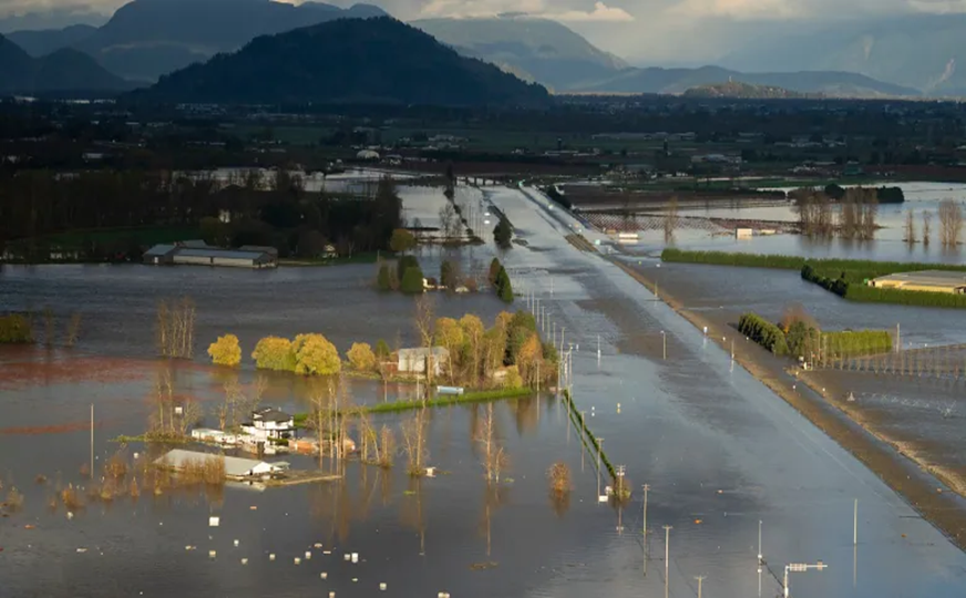
Flooding in the Fraser Valley, BC, in 2021. Image credit: CBC
For current situational awareness when managing a river basin, we can combine a DEM or surface model with river network data and real-time stream gauge data, feed this into a flood model, and generate areas at risk for flooding at present. For future risk, we can combine this data with forecasted increases in rainfall, estimated increase to stream height, and then use this to estimate changes to flood risk due to climate change. We can run this based on different climate change model runs (GCMs and RCMs – global and regional climate models) to get a sense of what the range of risks are for different warming scenarios. One of the challenges with this approach is downscaling – that is, finding methods to project the results of a global climate forecast down to the local scale.
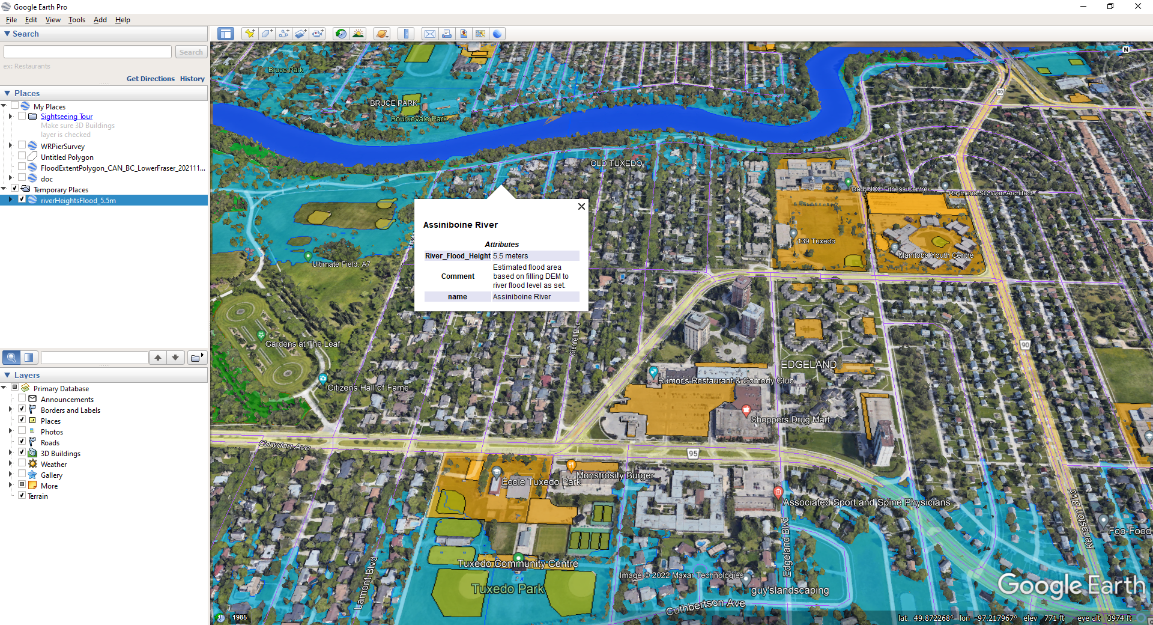
Assiniboine river flood risk estimate
Application: Risk Assessment for Disease Outbreaks
For another good example of situational awareness on a much tighter, shorter time frame, where even a few days can make all the difference, consider BlueDot and their response to the Covid-19 pandemic. BlueDot is a health information risk assessment platform that uses FME to help feed their analytics. To support situational awareness, their real-time data feeds are not IoT sensors but rather current information scraped from the web from news feeds, traffic information such as travel bookings, and various incident reports from around the world. This is all fed into their proprietary AI algorithms and analyzed for trends that exceed anticipated statistical norms. Using this approach, BlueDot was able to flag the onset of the Covid-19 pandemic in Wuhan in late December 2019—fully 9 days before the WHO triggered their first warnings. For critical threats of this magnitude, any lead time in an alert of this type can give decision makers the critical room they need to make timely decisions and ultimately improve their ability to safeguard our society and save lives.
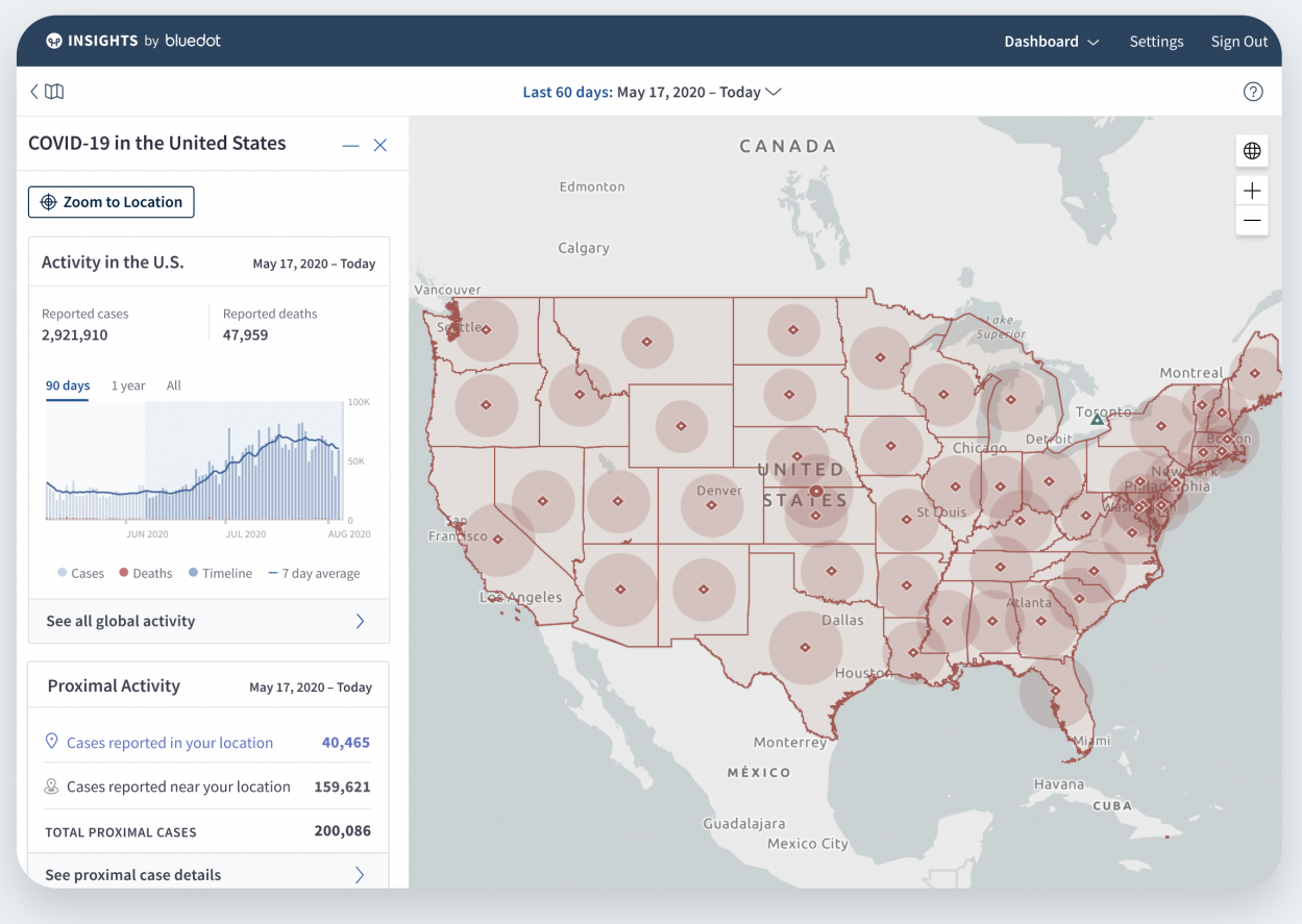
Covid-19 monitoring dashboard by bluedot
Addressing Situational Awareness in FME
FME is the ideal platform for enriching basemap and infrastructure data with real-time or latest status information. Given the best support for spatial, plus the comprehensive support for data streams of any type (JSON, XML, text), FME makes it easy to generate a current view of your environment and support situational awareness in any context.
Typically, data streams are read with some combination of HTTPCaller, web connections from FME Hub, FeatureReader using the data stream URL (JSON,XML etc) and FME Server automation listeners. FME Desktop is used to architect messaging workflows, which can be published to FME Server and included in automation workflows. Automations can be constructed to chain together service and sensor observations with message processing workspaces to support whatever data updates and notifications are required. These updates can be used to generate updated situation views, whether via notification messages, reports, or dashboards, to provide users with a current understanding of the system being managed. These automations can also be published to FME Cloud running on Amazon AWS, which is ideal when the source datastreams are cloud-based, as you can maintain close proximity between the source data and the processing. An excellent example of this is the real-time FME automation and notification platform constructed by Powerlink in Queensland, AU, to manage storm, fire, and flood risks to their power utility network.
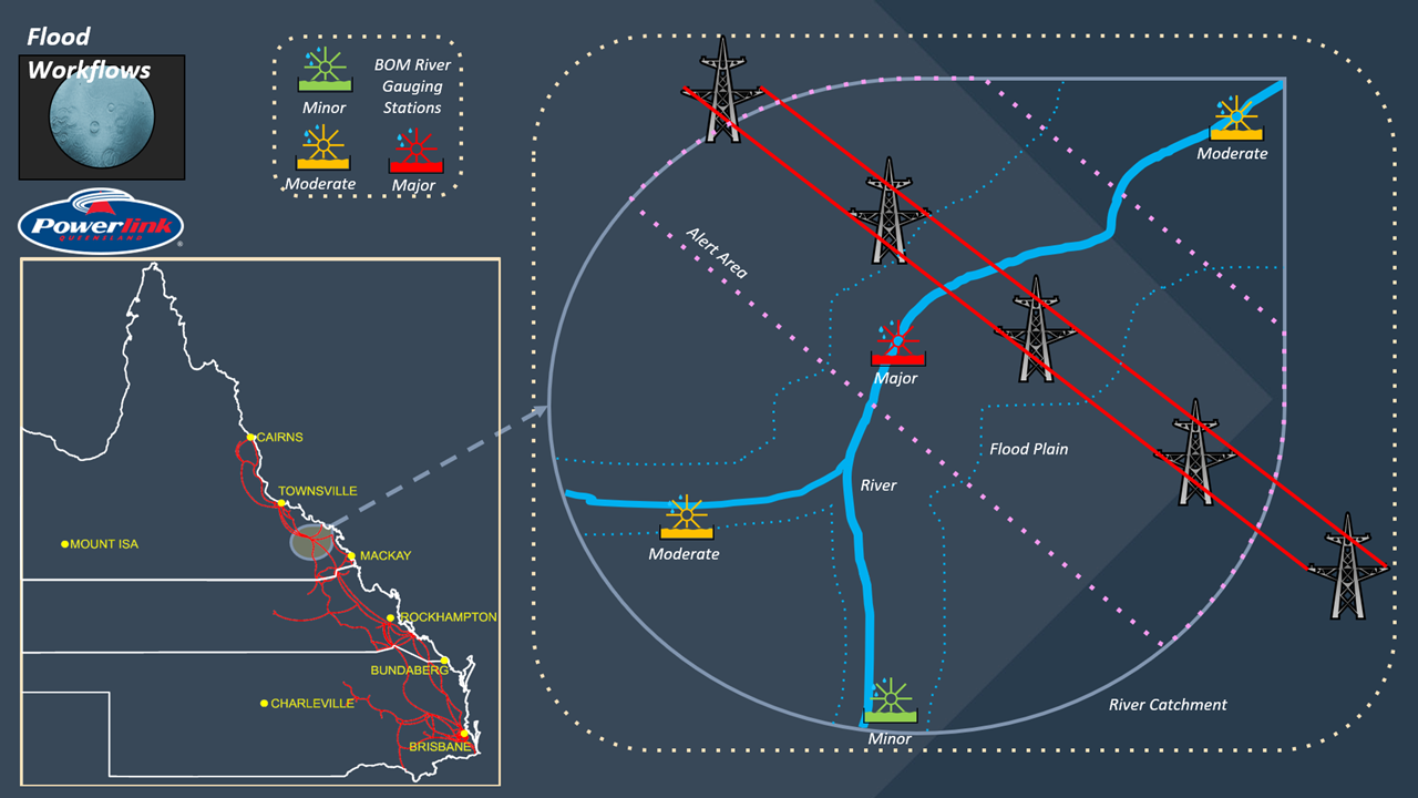
Powerlink flood monitoring and notification workflows
When it comes to enriching situational awareness with a view of the future, FME provides the ability to consume data from the niche numerical model outputs and time series typically generated by scientific climate and weather forecast models. Some standards used in this context are NetCDF, OGC CSW, HDF4, and a number of structured text formats that FME can be easily configured to consume.
Going forward, Safe Software is actively working with the wider geospatial community in the Open Geospatial Consortium (OGC) to explore approaches for integrating natural hazard model outputs and climate model results in order to better support disaster management and longer term climate change impact mitigation. This is accomplished by participation in relevant domain working groups, as well as by actively collaborating with other participants on the development of pilot projects related to disaster management and climate resilience.
We are also working to add support for new formats and standards related to situational awareness as they emerge. For example, we are tracking interest in the SensorThings API, Observations & Measurements, and Sensor Observation Service standards. Also, cloud native formats like COG, which we already support, and ZARR, which handles time series data cubes, are important for including outputs from forecast models. Cloud-native formats like these make deploying to the cloud and integrating web-based feeds much more efficient and scalable.
Conclusion
Situational awareness involves anything that helps us better understand our environment and support effective decision making, whether driving a car or developing a 10-year plan for a city. The FME data integration and automation platform is a toolset that makes supporting situational awareness that much easier, especially when dynamic spatial data is part of the mix. With our commitment to tracking industry trends and standards builds, you can be confident that solutions built on our platform will support the connectivity and transforms needed to make sure your data systems support the evolving needs of your enterprise.

Dean Hintz
Dean has a background in Math, Computer Science, GIS, and Environmental Science. He works with the Application Experts team helping customers and partners design and implement FME solutions to challenging data integration problems. He also serves as product manager for the XML team and coordinator for open standards. When not using FME, Dean likes to find new, creative ways to get lost, whether that be on the water, travelling, photography or in a good song or book.