This week I’ve had the privilege of attending the Location Intelligence conference in Denver. Though outside we enjoyed the beautiful mountain views afforded by the sunny, blue-sky Denver weather, inside it was consistently overcast. One of the conference themes was cloud computing and there was a wide variety of viewpoints and experiences presented on how businesses are planning to and are already using this new deployment model to solve spatial problems. The overwhelming message for me was that the future is here today, that the rate of adoption of a cloud approach is much higher than I thought previously.

Where is cloud computing on the Gartner Hype Cycle?
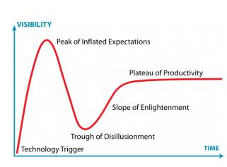
One of the first speakers at Location Intelligence was Victoria Kouyoumijan from ESRI. Victoria showed how ESRI was already using Amazon’s EC2 and S3 to power their ArcGIS Online offering. She also reflected on the Gartner Hype Cycle and wondered if cloud computing is just cresting the pinnacle of hype and heading toward to trough of disillusionment. While there is no doubt that the hype index of the “cloud” buzzword is very high, after seeing the talks at the conference and reflecting on our own experience at Safe, I think that this technology may be one where there is a much shallower trough and that we may already have moved past that trough and taken tentative steps toward the plateau of productivity.
As evidence for this, Paul Bissett of WeoGeo showed information from Spiceworks that 56% of small and medium businesses are already using cloud services, primarily in the areas of web hosting, email and online data backup. GeoEye was cited in several talks as already today using cloud services to provide solutions to both the data processing and data distribution challenges of the mindboggling raster data volumes that their sensors are gathering. Mark Sundt of Appistry spoke of how his clients are using private internal clouds (which have a lower cost per CPU cycle and leave control in the hands of the organization) and then bursting out onto public clouds to handle peak loads in a very cost effective way. Philip O’Doherty of eSpatial described how customers today are deploying their GIS for the Web. Finally, there was CH2M Hill’s Enterprise Spatial Solutions (ESS) GeoCity GIS-as-a-service, which targets small municipalities and frees them from maintaining any of the traditional GIS infrastructure on their own. CH2M Hill got tongues wagging with their claim that they could move in and set up an organization in 60 days, and they have a track record with dozens of sites to prove it.
All of this says to me that the future is already here, and that for us as geospatial professionals, the question is not if there are clouds in our future, but where they already are and how we can ride them to maximize the value we provide to our clients and customers. What do you think?

Try not to get hit by those geospatial burgers falling from the cloud.

Dale Lutz
Dale is the co-founder and VP of Development at Safe Software. After starting his career working spatial data (ranging from icebergs to forest stands) for many years, he and other co-founder, Don Murray, realized the need for a data integration platform like FME. His favourite TV show is Star Trek, which inspired the names for most of the meeting rooms and common areas in the Safe Software office. Dale is always looking to learn more about the data industry and FME users. Find him on Twitter to learn more about what his recent discoveries are!


